Contact
info@antiquarianquist.com
+31 (0)78 631 88 67
Voorstraat 50
3311 ER Dordrecht
The Netherlands
 We accept:

Disclaimer
Privacy policy
info@antiquarianquist.com
+31 (0)78 631 88 67
Voorstraat 50
3311 ER Dordrecht
The Netherlands
Disclaimer
Privacy policy
| Homepage | Collections | Contact | Newsletter | Order Info | Our shop |

All our items are in stock!
Books
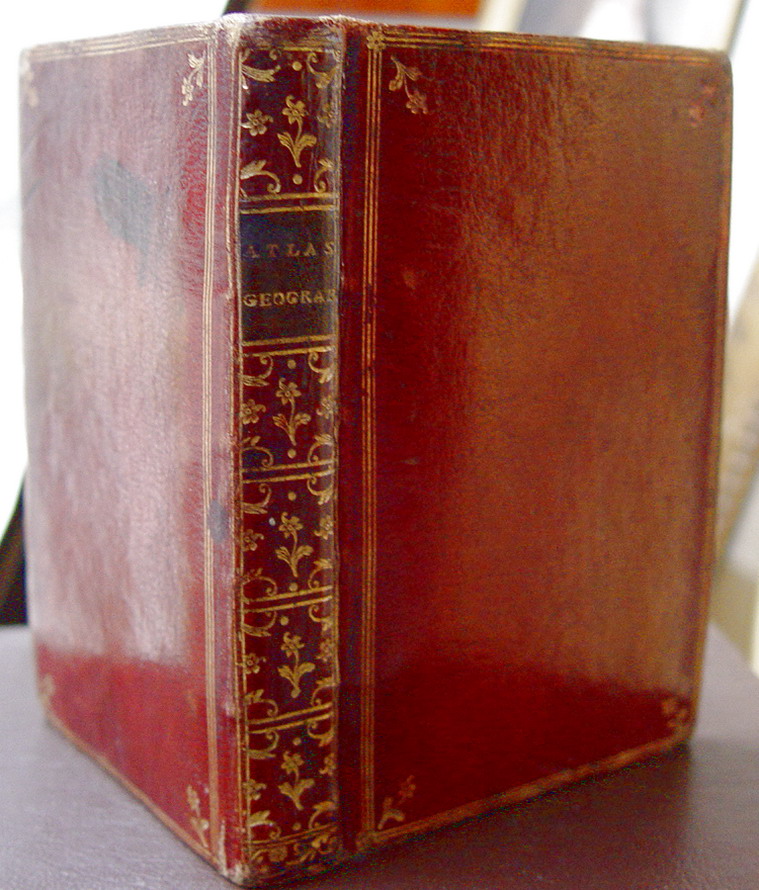
| Title | Atlas Geografique Contenant La Mappemonde Et Les Quatre Parties, Avec Les Different Etats |
| Author | Zannoni, Rizzi |
| Edition | New Edition |
| Published | Lattré & St.Jacques Paris & Bordeaux 1775 |
| Illustrator | Zannoni, Rizzi |
| Description | Allegorical, engraved frontispice, engraved title, and second engraved title. 1 print; "Sphere de Ptolomée" and 30 detailed maps. [all appr. 10,5 x 12,2 cm.] all delicately coloured by a contemporary hand. Contains: Worldmap Oriental & Occidental, l'Europe, l'Asie, l'Afrique, Amerique septrentrionale, Amerique meridionale, Golfe du Mexique, Isles Brittaniques, Danemarck, Suede et Norwege, Russie d'Europe, France,France 1ere/ 4eme Partie, Flandre, Empire d'Allemagne, [et div. sections] Roy. de Prusse, la Pologne, Italie and Turqui d'Europe Fine original red Morocco binding, A.E.G. with corner fleurons and triple gilt filet lines, richly gilded spine with gilt lettering and title label. Size:12,8 x 8,7 cm. Published with 2 title pages: Etrennes Geografiques "1775" and Atlas Geographique 1762. A very well kept little book, with only minor wear to extremities. Rizzi-Zannoni born 1736 in Naples was renowned from an early age as one of the finest cartographers in Europe. He worked also as an astronomer, surveyor and mathematician. He was the first to triangulate Poland and helped also in the French and English border survey of America in 1757. In 1781 the Bourbon rulers of Naples made him director of the Topographical Office. This was among the first governmental cartographic offices in Europe. Contens are as described by Geoffrey King in his 2-Nd. edition of Miniature Antique Maps, pp. 176 [with a repoduction of the title page] |
| Book condition | Very Good |
| Binding | Full-Leather, Gilt-Stamped |
| Book size | 12mo - over 6¾" - 7¾" tall |
 | |
| more pictures | |
| Price | |
| Order or get more information |